Monday, December 11, 2006
these boots were made for walking...
...and thats just what they did.
El Camino Inca to Machu Picchu
Day 1.
From Cusco, a bus took us down into the Sacred Valley, through Ollantaytambo, and on to km82 of the Inca Trail where the 4 day walk begins. There were four of us gringos, a guide, and 5 porters, who carried the tents, kitchen, and food. The first day´s hike was pretty gentle, a slow rise of 600m spread over 4 hours walking. We walked past Llaqtapata, a ruin discovered after Machu Picchu on the bank of the Urubamba river, and once we got to Wayllabamba we settled in for the evening. This was were I got the first impression of how amazing the porters were; as we ambled (the pace of the walk was never very quick) along the trail chatting, they ran, carrying huge bags upto 40 pounds, and some of them (from other groups) wearing only thin leather sandals on their feet. By the time we got to the campsite, the tents had already been set up, and they were hanging out listening to their radio and eating popcorn. It felt strange having people basically carry my shit for me, but without it, the whole trek would be impossible, or at least not very enjoyable. Juan Carlos, one of the porters told me that they usually do the trail 3 or 4 times a month to make some cash and spend the rest of their time working on the farms in their community (they were all from the same small town south of the sacred valley).
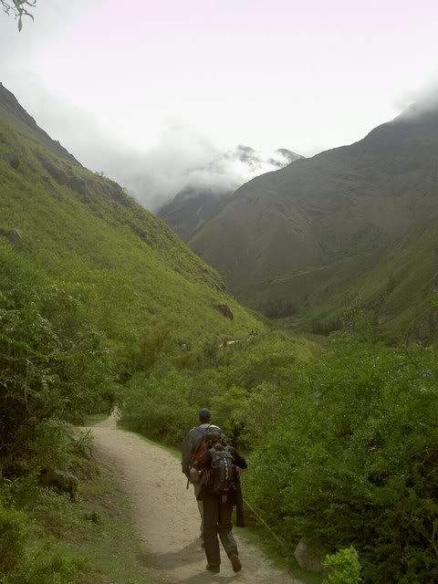
the start of the trail
llaqtapata
Day 2.
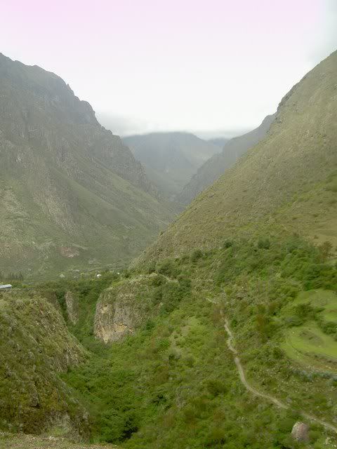
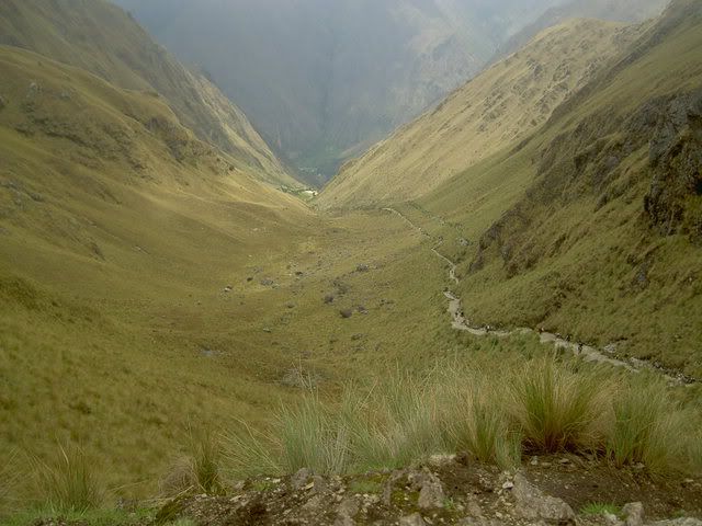
The second day included the hardest climb of the trek: up to the Dead Woman's Pass at 4200m above sea level. From the campsite it was about 2-3 hours up the increasingly steep trail/staircase. As the altitiude increased, we moved out of the subtropical cloud forest up into high andean grasslands. Occaisonally, with breaks in the clouds and fog, snowy peaks from the neighboring ranges poked through, making the climb more dramatic. After the pass, there was a long stairway down the other side following a small river/waterfall down to the second campsite. Coming into the trek, I'd heard that this was the most demanding and draining section, the long steep climb followed by the almost as difficuly descent. I felt ok at the top of the pass, maybe just a bit out of breath a sweaty, but my heart wasnt pounding too hard and my legs werent trembling. Maybe the mouthfuls of coca leaves helped afterall? People in the andes chew coca leaves to help deal with the altitude; the plant also helps to stave off hunger and settles the stomach. During the Inca empire it was crucial for the functioning of the network of chaskis or messengers who would carrry messages (encoded in tied strings called quipus) along the breadth of the Inca empire, at its peak stretcing from central Chile to southern Columbia. The messangers would run 50-60kms a day, carrying the messages they couldnt understand. Last year, in a race between the porters, a new record was set on the Inca trail when one ran the 42km (a marathon length) up and down the mountains to Machu Picchu in 3h45m, the walk that I did in 3.5 days or so.
the valley leading up to the dead woman's pass
looking down from dead woman's pass
Day 3.
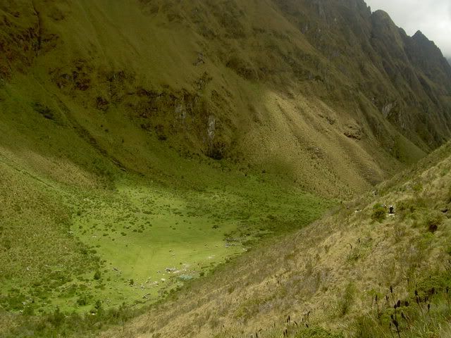
Normally the third day of the trek is the most beautiful, as the trail passes through 2 more high passes and along the side of a series of mountains, giving views of the spectacular valleys and ranges all around. Unfortunately, it was foggy all morning, and poured from 12 onwards, so this was the least pleasant section. Early in the day we passed the egg shaped ruin of runquracay, a resting place for chaskis and pilgrims heading to Machu Picchu. After a long wet hike up and down the 2 passes, we reached the campsite, and a few minutes later the skies cleared showing us what we'd been missing all day. By nighttime it was perfectly clear, and the nightsky was lit up by thousands of stars...a few of the shooting. But we couldnt stay up too late stargazing, since the next day was a 4am wake up call for the final leg through the sun gate into Machhu Picchu itself.
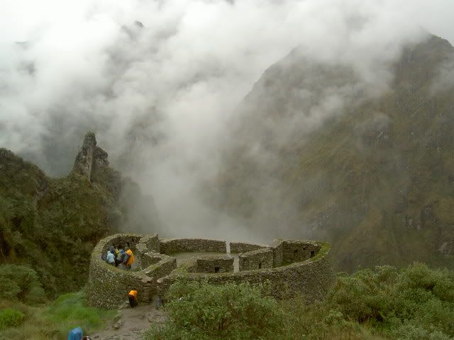
runkuraqay
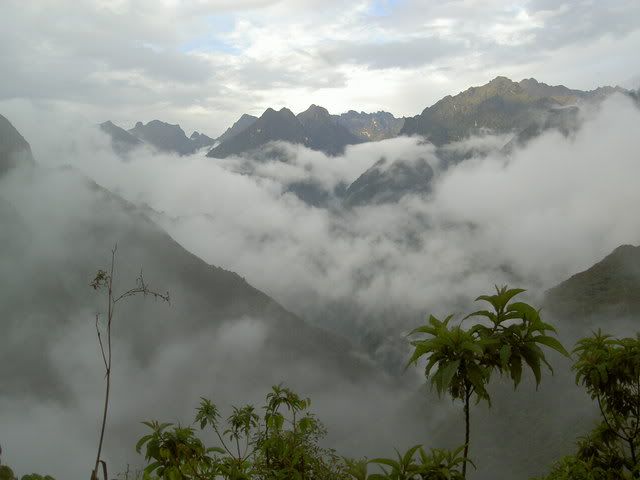
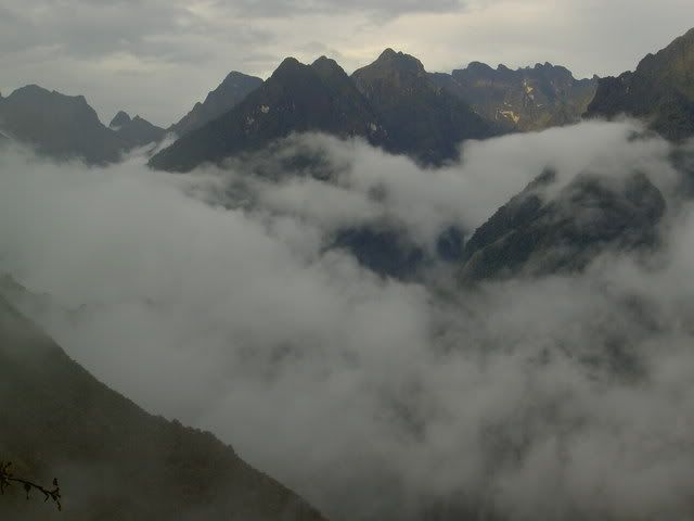
mountains in the mist, from the campsite in the early evening
Day 4.
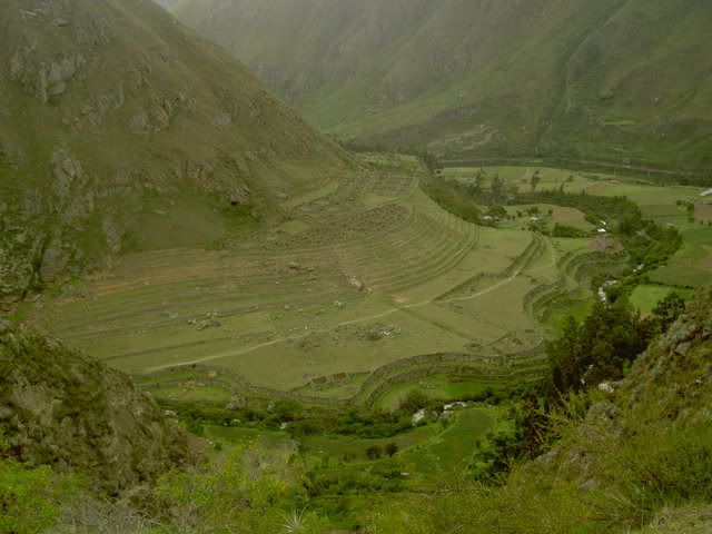
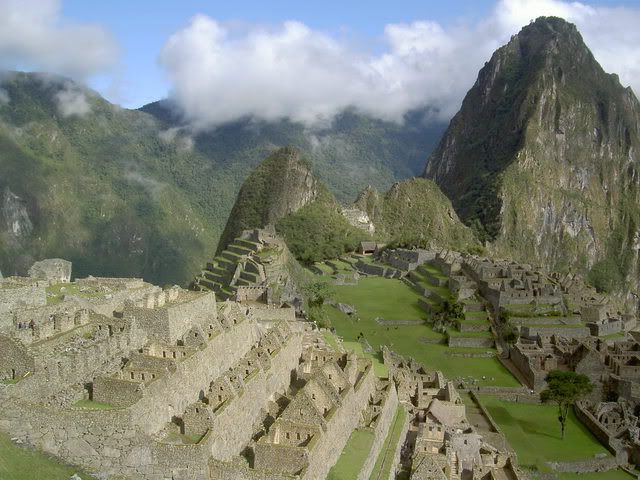
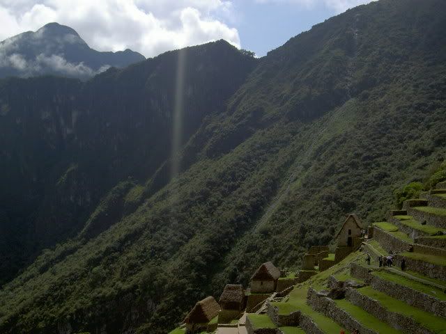
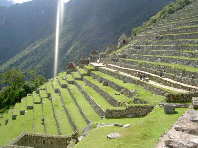
A bright and early start got us to Intipunku, or the sun gate, at about 6am. This was the principal enterance to Machu Pichu for pilgrims, commercial traffic followed the river along the bottom of the valley. The high route, that we took, was the one used by pilgrims who saw the Inca trail as a path to spiritual improvement. Many of the ruins along the trail feature fountains where the pilgrims would take purifiying showers. From the sungate, Machu Picchu is sprawled out below. A 40 minute descent later, we arrived and wandered around the site learning about its temples, its class based spacial divisions, and its importance as a ceremonial center for the Incas. Afterwards, we rode a bus down the valley floor, and rode the train back into Cusco, the return trip abour 3hours for the 4 days of walking to get there. But, despite the rainy sunday, it was definatley worthwhile...the views, the sites, and the feeling of accomplishment more than made up for being a bit soggy.
machu picchu from the sungate
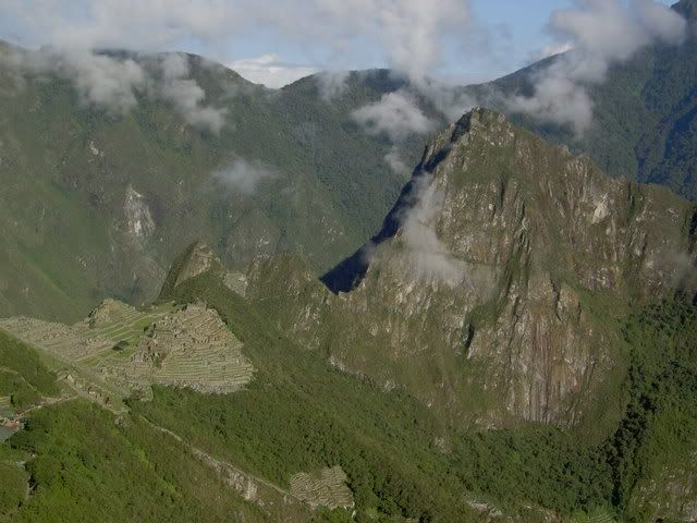
machu picchu and huayna pichu
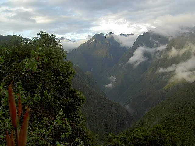
from macchu pichu towards the sun gate (on the 1st ridge), high on the 2nd ridge is one of the passes from the 3rd day.
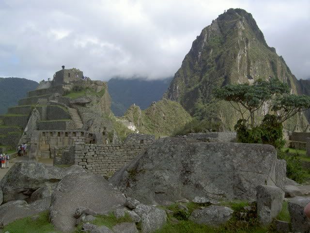
machu pichu
More Pictures Here
El Camino Inca to Machu Picchu
Day 1.
From Cusco, a bus took us down into the Sacred Valley, through Ollantaytambo, and on to km82 of the Inca Trail where the 4 day walk begins. There were four of us gringos, a guide, and 5 porters, who carried the tents, kitchen, and food. The first day´s hike was pretty gentle, a slow rise of 600m spread over 4 hours walking. We walked past Llaqtapata, a ruin discovered after Machu Picchu on the bank of the Urubamba river, and once we got to Wayllabamba we settled in for the evening. This was were I got the first impression of how amazing the porters were; as we ambled (the pace of the walk was never very quick) along the trail chatting, they ran, carrying huge bags upto 40 pounds, and some of them (from other groups) wearing only thin leather sandals on their feet. By the time we got to the campsite, the tents had already been set up, and they were hanging out listening to their radio and eating popcorn. It felt strange having people basically carry my shit for me, but without it, the whole trek would be impossible, or at least not very enjoyable. Juan Carlos, one of the porters told me that they usually do the trail 3 or 4 times a month to make some cash and spend the rest of their time working on the farms in their community (they were all from the same small town south of the sacred valley).
the start of the trail
llaqtapata
Day 2.
The second day included the hardest climb of the trek: up to the Dead Woman's Pass at 4200m above sea level. From the campsite it was about 2-3 hours up the increasingly steep trail/staircase. As the altitiude increased, we moved out of the subtropical cloud forest up into high andean grasslands. Occaisonally, with breaks in the clouds and fog, snowy peaks from the neighboring ranges poked through, making the climb more dramatic. After the pass, there was a long stairway down the other side following a small river/waterfall down to the second campsite. Coming into the trek, I'd heard that this was the most demanding and draining section, the long steep climb followed by the almost as difficuly descent. I felt ok at the top of the pass, maybe just a bit out of breath a sweaty, but my heart wasnt pounding too hard and my legs werent trembling. Maybe the mouthfuls of coca leaves helped afterall? People in the andes chew coca leaves to help deal with the altitude; the plant also helps to stave off hunger and settles the stomach. During the Inca empire it was crucial for the functioning of the network of chaskis or messengers who would carrry messages (encoded in tied strings called quipus) along the breadth of the Inca empire, at its peak stretcing from central Chile to southern Columbia. The messangers would run 50-60kms a day, carrying the messages they couldnt understand. Last year, in a race between the porters, a new record was set on the Inca trail when one ran the 42km (a marathon length) up and down the mountains to Machu Picchu in 3h45m, the walk that I did in 3.5 days or so.
the valley leading up to the dead woman's pass
looking down from dead woman's pass
Day 3.
Normally the third day of the trek is the most beautiful, as the trail passes through 2 more high passes and along the side of a series of mountains, giving views of the spectacular valleys and ranges all around. Unfortunately, it was foggy all morning, and poured from 12 onwards, so this was the least pleasant section. Early in the day we passed the egg shaped ruin of runquracay, a resting place for chaskis and pilgrims heading to Machu Picchu. After a long wet hike up and down the 2 passes, we reached the campsite, and a few minutes later the skies cleared showing us what we'd been missing all day. By nighttime it was perfectly clear, and the nightsky was lit up by thousands of stars...a few of the shooting. But we couldnt stay up too late stargazing, since the next day was a 4am wake up call for the final leg through the sun gate into Machhu Picchu itself.
runkuraqay
mountains in the mist, from the campsite in the early evening
Day 4.
A bright and early start got us to Intipunku, or the sun gate, at about 6am. This was the principal enterance to Machu Pichu for pilgrims, commercial traffic followed the river along the bottom of the valley. The high route, that we took, was the one used by pilgrims who saw the Inca trail as a path to spiritual improvement. Many of the ruins along the trail feature fountains where the pilgrims would take purifiying showers. From the sungate, Machu Picchu is sprawled out below. A 40 minute descent later, we arrived and wandered around the site learning about its temples, its class based spacial divisions, and its importance as a ceremonial center for the Incas. Afterwards, we rode a bus down the valley floor, and rode the train back into Cusco, the return trip abour 3hours for the 4 days of walking to get there. But, despite the rainy sunday, it was definatley worthwhile...the views, the sites, and the feeling of accomplishment more than made up for being a bit soggy.
machu picchu from the sungate
machu picchu and huayna pichu
from macchu pichu towards the sun gate (on the 1st ridge), high on the 2nd ridge is one of the passes from the 3rd day.
machu pichu
More Pictures Here
Labels: cusco, inca trail, machu picchu, sacred valley
# posted by jacob @ 9:56 PM 
![]()